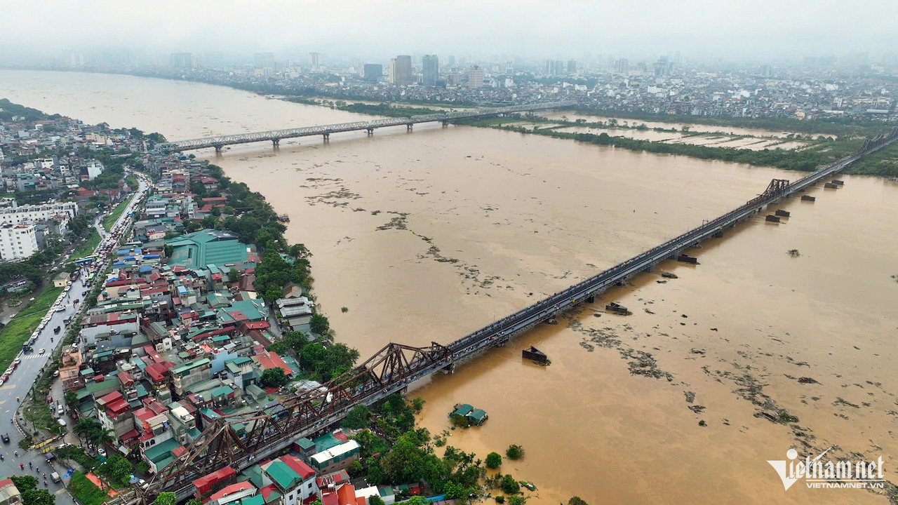
With the Red River running through the heart of Hanoi in a neglected state, city officials have greenlit a major public-private initiative to revitalize its banks. Experts, however, warn that safety, flood drainage, and hydrological impacts must be carefully considered.
Awakening the ‘forgotten’ land along the Red River
The Hanoi People's Committee has approved a proposal by Deo Ca and Van Phu consortiums to study the “Red River Boulevard and Riverside Landscape Project,” to be implemented under a public-private partnership (PPP) through a build-transfer (BT) contract.
The strategic development will span approximately 7,800 hectares, extending about 40 kilometers across 13 districts and 55 wards and communes of the capital.
Despite its prime geographic and cultural value, this riverside zone has long been underutilized due to fragmented development and lack of cohesive infrastructure. The public space potential remains largely untapped.
To unlock this “sleeping” potential, the Red River Boulevard project proposes more than just a transportation corridor connecting Hanoi with Hung Yen and Phu Tho. It envisions a vibrant cultural and ecological corridor with terraced parks, riverside promenades, public squares, tourism and service complexes, and community spaces.
Red River needs urgent improvement, but safely
Speaking with VietNamNet, former Deputy Minister of Agriculture and Rural Development Dao Xuan Hoc stressed the importance of turning the Red River into a powerful asset for Hanoi.
He reiterated his long-standing sentiment: “No other capital city in the world has a river running through it as neglected as the Red River.”
“Renovation is essential. If well executed, it could become a tremendous source of growth for Hanoi. However, any development must ensure the safety of flood dikes, which are critical to protecting lives,” he cautioned.
Hoc emphasized the need for comprehensive planning, aligning with Hanoi’s new urban master plan, which identifies the Red River banks as one of five key development corridors.
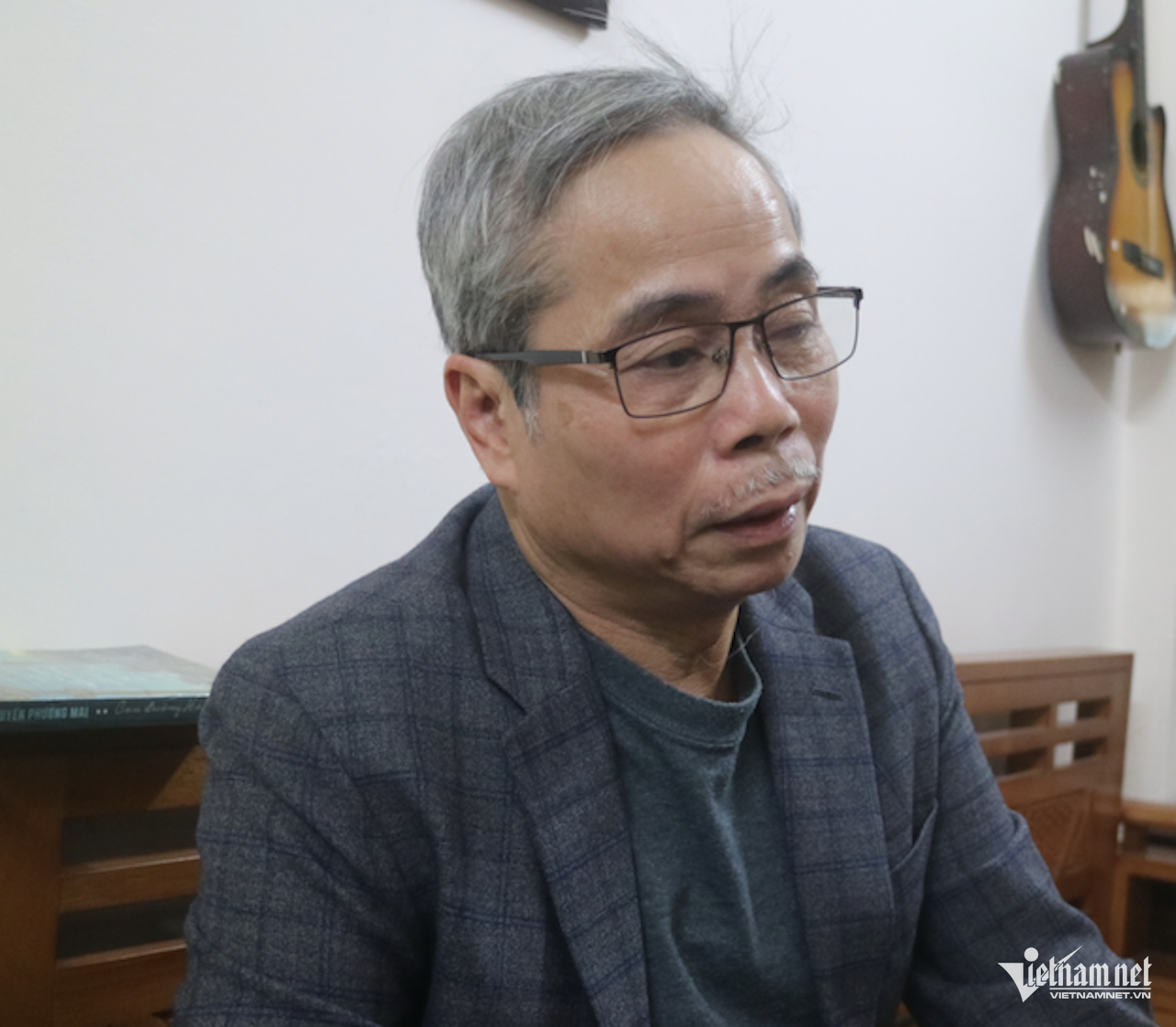
Architect Tran Huy Anh of the Hanoi Architects Association offered a contrasting perspective, asserting, “The most beautiful landscape along the Red River is the river itself.”
Under the Capital Law passed by the National Assembly in 2024, new dikes may be built in accordance with flood control and river management plans, and riverside land may be used for public facilities as long as the terrain remains undeveloped to preserve flood pathways.
Hanoi’s 2021–2030 master plan, with a vision to 2050, approved in 2024, includes proposals to build weirs on the Red and Duong Rivers to elevate water levels during dry seasons, enhance landscapes, revive rivers, and ensure stable water supplies for Hanoi’s socio-economic needs.
Speaking in the National Assembly on June 20, 2024, lawmaker Hoang Van Cuong-one of the master plan’s architects-highlighted the plan’s triple objectives, including saving 5 billion cubic meters of clean water for domestic and industrial use.
Architect Anh pointed out that storing 5 billion cubic meters in a short time would require vast water retention space. A 5-meter-deep reservoir would need 1,000 square kilometers. Yet, the inner-dike areas along 29 km of the Da River and 129 km of the Red River through Hanoi only span 400 square kilometers.
If dams such as Xuan Quang and Long Tuu are built, they could store up to 2 billion cubic meters across these floodplains. While this could help wash away pollutants, it would also submerge roads and riverside infrastructure.
“No matter how many parks, roads, or cultural venues are built, if the Red River runs dry, they will decay. If water levels rise and construction in the floodplain isn’t elevated, all investments risk being submerged,” Anh warned.
He also noted a lack of comprehensive research on the Red River’s vulnerabilities over the past 25 years and into the next 25-issues such as riverbed deformation from sand mining, flood and drought risks, and water pollution.
“If a visionary and responsible investor can tackle these challenges, Hanoi could move toward a more secure and sustainable future,” he said.
The proposed Red River Boulevard would run along the river’s right bank (as per flow direction) from Hong Ha Bridge to Me So Bridge, tracing Ring Road 4. On the left bank, it would connect from Hong Ha Bridge to the planned Cultural Heritage and Economic Development Road.
The plan includes 22 kilometers of elevated roadways, 7.6 kilometers of parallel roads, and 2.3 kilometers of tunnels, with cross-sections of 4 to 6 lanes. Green space elements, including parks and iconic structures, would cover roughly 3,000 hectares, offering venues for traditional and modern cultural activities, as well as craft villages.
N. Huyen