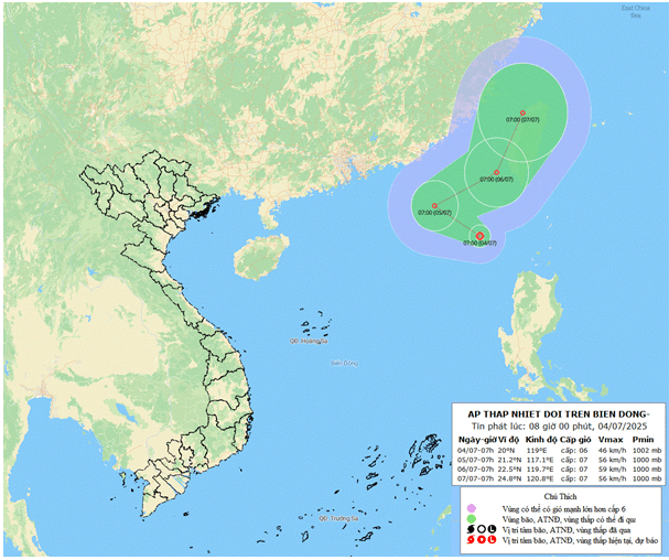
In the next 24 hours, the tropical depression will continue on a west-northwest path at 10-15 km/h and is likely to intensify. By 7:00 AM tomorrow (July 5), it is expected to be located about 780 kilometers northeast of the Hoang Sa archipelago, with wind strength at levels 6-7 and gusts at level 8.
In the following 24 hours, the system will shift direction and move east-northeast at a faster speed of 15-20 km/h, continuing to intensify. By 7:00 AM on July 6, it is forecast to be over the southwestern waters of Taiwan (China), with wind strength reaching level 7 and gusts at level 9.
Between 48 to 72 hours later, the tropical depression is expected to continue moving north-northeast at a speed of 15-20 km/h.
Due to the impact of the tropical depression, the northeastern area of the northern East Sea will experience showers and thunderstorms with strong winds at levels 6-7, gusting up to level 9, causing rough seas and wave heights of 2-4 meters.
A tropical convergence zone connected to the depression will bring scattered showers and thunderstorms throughout today and tonight to the Gulf of Tonkin, the northern East Sea (including the Hoang Sa archipelago), the eastern central East Sea, coastal waters from southern Quang Tri to Quang Ngai, from Ca Mau to An Giang, and the Gulf of Thailand. Thunderstorms may bring whirlwinds, strong gusts of level 6-7, and waves over 2 meters.
Additionally, the coastal waters from Lam Dong to Ca Mau will experience southwest winds at level 5, sometimes level 6, with gusts up to level 7, causing waves of 2-3 meters and rough seas.
All vessels operating in these areas are at risk of being affected by whirlwinds and strong gusts.
Bao Anh