A tropical depression is currently active over the northern part of the East Sea, packing winds of level 6 (39–49 km/h) and gusts up to level 8, with forecasts indicating continued intensification in the coming days.
On land, heavy localized rains are expected across northern Vietnam, the south-central coast, Central Highlands, and southern regions, posing high risks of flash floods and landslides.
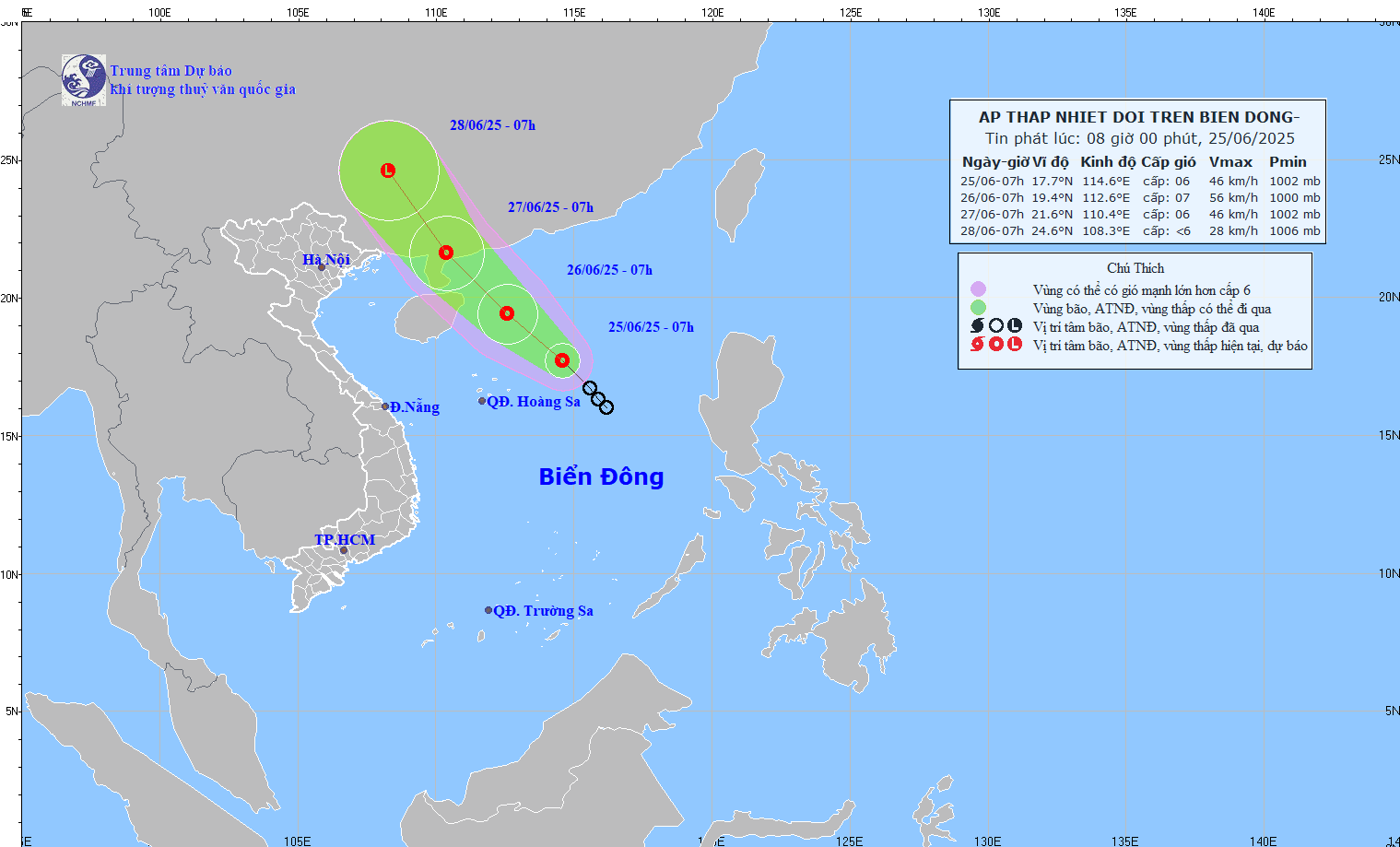
Movement path of the tropical depression as of the morning of June 25. Source: NCHMF
According to the National Center for Hydro-Meteorological Forecasting, as of 7 a.m. on June 25, the center of the tropical depression was located at approximately 17.7°N latitude and 114.6°E longitude, about 360 km east-northeast of the Paracel Islands.
The strongest winds near the center reached level 6, with gusts of level 8. The system is moving northwest at a speed of 15–20 km/h.
Forecast for the next 24 to 48 hours:
By 7 a.m. on June 26, the depression is expected to be around 180 km east of Hainan Island, China, with intensified winds of level 6-7 and gusts up to level 9. The danger zone in the East Sea over the next 24 hours (winds level 6 and above, gusts level 8 and above) is between latitudes 16.5°N to 21°N and longitudes 111.5°E to 115.5°E. The risk level at sea due to strong winds is rated level 3.
By 7 a.m. on June 27, the system is forecast to move northwest at approximately 15 km/h, gradually weakening as it reaches southwestern Guangdong Province in China. At this point, winds are expected to decrease to level 6 with gusts at level 8. The danger zone will extend northward, above latitude 18°N and between longitudes 109°E to 113.5°E, maintaining a level 3 risk rating.
Forecast for the next 48 to 72 hours:
The tropical depression is expected to continue moving north-northwest at 15–20 km/h while weakening further. The northern East Sea, including the Paracel Islands’ surrounding waters, is forecast to experience thunderstorms with winds of level 6-7 and gusts up to level 9. Waves are expected to reach heights of 2–4 meters, creating rough sea conditions.
Ships operating in this region face high risks from thunderstorms, waterspouts, strong winds, and high waves. Authorities advise strict monitoring and proactive precautions.
Heavy rainfall across multiple regions in Vietnam

Due to a northwestern-southeastern oriented low-pressure trough extending across central Vietnam and the mid-East Sea, combined with moderate southwest monsoon activity in the southern regions, widespread rain is expected throughout the country.
Specifically, from last night into this morning (June 25), showers and scattered thunderstorms occurred in the mountainous northern regions and the Central Highlands, with some areas experiencing very heavy rain. Rainfall totals between 7 p.m. June 24 and 8 a.m. June 25 include: Lieu Do (Yen Bai) 317.4mm, Tien Nguyen (Ha Giang) 225.4mm, Dak Hring (Kon Tum) 136.2mm.
Today and tonight, scattered showers and thunderstorms are forecast in the northwest and Red River Delta, with localized heavy rain reaching 15–30mm and isolated areas exceeding 80mm.
This evening and tonight, the Viet Bac region will experience moderate to heavy rainfall and scattered thunderstorms, with amounts ranging from 15–40mm, and localized rainfall possibly exceeding 150mm.
Meanwhile, the south-central coast is forecast to have scattered showers and thunderstorms this evening, with local heavy rain between 10–30mm, and isolated areas exceeding 80mm. The Central Highlands and southern regions will also see moderate to heavy showers and thunderstorms, with rainfall between 15–40mm and some areas receiving over 100mm.
The meteorological agency warns that thunderstorms may bring tornadoes, lightning, hail, and strong gusts. Heavy localized rainfall may cause flash floods in small rivers and streams, landslides on steep slopes, and flooding in low-lying areas.
Bao Anh